
Keyword
Ship: Diamantina
87 record(s)
Type of resources
Topics
Keywords
Contact for the resource
Provided by
Formats
Update frequencies
Status
draft
-
Primary productivity point data from Australian waters that has been mapped using MapInfo. Data collected from oceanographic surveys conducted between 1959 and 1964 onboard the vessels "Gascoyne" and "Diamantina". Primary Production integrated to 100m grams Carbon per square metre per day. These Mapinfo layers have been produced by CSIRO for the National Oceans Office, as part of an ongoing commitment to natural resource planning and management through the 'National Marine Bioregionalisation' project. Variations in onscreen colour representation or printed reproduction may affect perception of the contained data.
-
Zooplankton biomass point data from southern Australian waters that has been mapped using MapInfo. Data collected from oceanographic surveys conducted between 1959 and 1964 onboard the vessels "Gascoyne" and "Diamantina". These MapInfo layers have been produced by CSIRO for the National Oceans Office, as part of an ongoing commitment to natural resource planning and management through the 'National Marine Bioregionalisation' project. Variations in onscreen colour representation or printed reproduction may affect perception of the contained data.
-
Primary production estimates were made using the uptake of radioactive carbon during a series of 27 research voyages from the naval frigates "Diamantina" and "Gascoyne" in the period 1959-1965. A variety of in-situ and simulated in-situ incubation techniques were used to produce the data sets. The data have been extracted from the CSIRO Division of Fisheries and Oceanography Oceanographical Cruise Reports and collated into an excel spreadsheet. The excel file has a series of Worksheets in it, with each worksheet containing information relevant to the data set. These worksheets list the research voyages included in the data set, the methods used to measure primary production on each cruise, station data, and the data arranged for mapping. In additional worksheets, the data has been shortened by depth, incubation period, and a real hourly and daily primary production. The data set is about 1.3 MB, and many of the stations included have zooplankton biomass data in the zooplankton file. This data has been produced by CSIRO for the National Oceans Office, as part of an ongoing commitment to natural resource planning and management through the 'National Marine Bioregionalisation' project.
-
Primary Productivity point data from northern Australian waters that has been mapped using MapInfo. Data collected from oceanographic surveys 1959-1964 onboard the vessels "Gascoyne" and "Diamantina". Zooplankton biomass, milligrams per cubic metre. This GIS layer has been produced by CSIRO for the National Oceans Office, as part of an ongoing commitment to natural resource planning and management through the 'National Marine Bioregionalisation' project. Variations in onscreen colour representation or printed reproduction may affect perception of the contained data.
-
Zooplankton biomass point data, from Australian waters, that has been mapped using MapInfo., from data collected from oceanographic surveys conducted between 1959 and 1964 onboard the vessels "Gascoyne" and "Diamantina". This mapinfo grid has been produced by CSIRO for the National Oceans Office, as part of an ongoing commitment to natural resource planning and management through the 'National Marine Bioregionalisation' project. Variations in onscreen colour representation or printed reproduction may affect perception of the contained data.
-
Mapset showing primary productivity in northern Australian waters. Data collected from oceanographic surveys conducted between 1959 and 1964 onboard the vessels "Gascoyne" and "Diamantina". Primary Production integrated to 100m, grams Carbon per spare metre per day. This map has been produced by CSIRO for the National Oceans Office, as part of an ongoing commitment to natural resource planning and management through the 'National Marine Bioregionalisation' project.
-
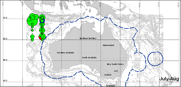
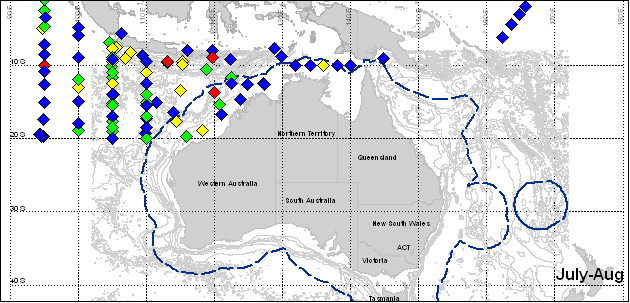
Mapset showing zooplankton biomass in the Timor Triangle. Data was collected from oceanographic surveys conducted between 1959 and 1964 onboard the vessels "Gascoyne" and "Diamantina". Clarke-Bumpus Horizontal Haul, zooplankton biomass milligrams per cubic metre. These maps have been produced by CSIRO for the National Oceans Office, as part of an ongoing commitment to natural resource planning and management through the 'National Marine Bioregionalisation' project.
-
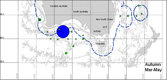
Mapset showing zooplankton biomass in southern Australian waters. Data collected from oceanographic surveys conducted between 1959 and 1964 onboard the vessels "Gascoyne" and "Diamantina". Clarke-Bumpus Oblique Haul, zooplankton biomass milligrams per cubic metre. These maps have been produced by CSIRO for the National Oceans Office, as part of an ongoing commitment to natural resource planning and management through the 'National Marine Bioregionalisation' project.
-

Mapset of zooplankton biomass seasonality along 110º E, Indian Ocean using a Standard Net (samples from return-trips along the 110º E latitude line were shifted to 105º E). Data was collected from Oceanographic surveys conducted between 1959 and 1965 onboard the vessels "Gascoyne" and "Diamantina". These maps have been produced by CSIRO for the National Oceans Office, as part of an ongoing commitment to natural resource planning and management through the 'National Marine Bioregionalisation' project.
-
This record is an overview entry for biological data collected on Diamantina cruise Dm 1/62. This cruise took place in the northeast Indian Ocean, Banda Sea and Java Sea during 12 February to 25 March 1962, under the leadership of B. Newell & D. Rochford. Biological data collected on this cruise include primary production rates; organisms with/without chlorophyll, total particles and occurrence of dinoflagellates from phytoplankton stations; pigment samples; and zooplankton biomass. Please note: This metadata record is a preliminary entry derived from information in the cruise report. Individual data types - which may span several cruises - will be indexed separately within this metadata system in due course.